
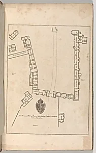
Ground plan of Ancient Palace at Eltham, from Edward Hasted's, The History and Topographical Survey of the County of Kent, vols. 1-3
John Bayly
1777
Medium
Etching and engraving
Dimensions
Book: 17 5/16 × 11 × 13/16 in. (44 × 28 × 2 cm) Sheet: 16 15/16 × 10 5/8 in. (43 × 27 cm) Plate: 10 1/16 × 14 in. (25.5 × 35.5 cm)
Classification
Books
Department
Drawings and Prints
Museum
Metropolitan Museum of Art, New York, NY
Credit
Gift of Bonnie and Manuel Schonhorn, 2014
Accession Number
2014.599.1
Rights
Public Domain
Tags
Architecture