
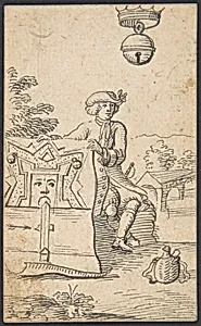
Shell King: A Man with a Map of a Fortification
1712 or later
Medium
Pen and black ink
Dimensions
sheet: 3 9/16 x 2 5/16 in. (9 x 5.9 cm)
Classification
Drawings
Department
Drawings and Prints
Museum
Metropolitan Museum of Art, New York, NY
Credit
Purchase, Jean A. Bonna Gift, 2007
Accession Number
2007.223.39
Rights
Public Domain
Tags
Art Historical Context
Behold the whimsical "Shell King: A Man with a Map of Fortification," a delicate pen and black ink drawing by Johannesenberg, created in 1712 or later. Measuring just 3 9/16 x 2 5/16 inches, this intimate sheet from the Metropolitan Museum of Art's Drawings Prints collection captures a quirky figure—a man clutching a detailed map of fortifications—evoking the era's fascination with cartography, defense, and perhaps fantastical allegory through its intriguing title. Pen and black ink was a favored medium in the early 18th century for precise, spontaneous sketches, allowing artists like Brandenberg to render fine lines and intricate details on a small scale. Here, the technique highlights the taut precision of the map's geometries against the human form, blending portraiture with topographic accuracy. Such works often served as studies or personal musings, reflecting the intellectual pursuits of the Dutch Golden Age's twilight, when maps symbolized power, exploration, and ingenuity. Acquired through the Jean A. Bonna Gift in 2007, this drawing invites us to ponder the "Shell King" moniker—hinting at a playful fusion of natural curiosity (shells as treasures of the sea) and martial strategy. It's a charming window into an artist's inventive mind, perfect for contemplating how everyday sketches encapsulated the period's blend of science, imagination, and human endeavor.