
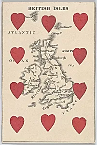
British Isles, from "Court Game of Geography"
1838–55
Medium
Engraving and hand coloring (watercolor)
Dimensions
3 3/4 × 2 1/2 in. (9.5 × 6.4 cm)
Classification
Prints|Ornament & Architecture
Department
Drawings and Prints
Museum
Metropolitan Museum of Art, New York, NY
Credit
Gift of the Estate of James Hazen Hyde, 1959
Accession Number
59.654.16(10)
Rights
Public Domain
Tags
Art Historical Context
Nestled among the Metropolitan Museum of Art's collection of prints, *British Isles, from "Court Game of Geography"*1838–55) is a delightful miniature engraving by brothers William and Henry Rock. just 3 3/4 × 2 1/2 inches, this hand-colored watercolor card depicts a detailed map of the British Isles blending cartography with the playful format of a playing card. Produced during the Victorian era, when educational toys surged in popularity, it forms part of a larger "Court Game" set designed to teach geography through gamified learning. The Rocks, skilled engravers, captured the islands' contours with precise lines typical of 19th-century printmaking, then added vibrant watercolor washes by hand to distinguish land, sea, and political boundaries. This technique not only ensured durability for repeated play but also lent an ornamental charm, aligning with the era's neoclassical tastes in maps as decorative art. Such cards transformed rote memorization into family entertainment, reflecting Britain's imperial pride and growing emphasis on public education. Today, this tiny treasure highlights how everyday objects like playing cards doubled as cultural tools, fostering geographic literacy amid the British Empire's expansion. A gift to the Met from the Estate of James Hazen Hyde in 1959, it invites visitors to appreciate the artistry in education's playful past.
About the Artist
William and Henry Rock · 1821–1884
William and Henry Rock were British brothers and publishers active in London during the mid-19th century, renowned for their innovative educational playing card games that blended art, geography, and entertainment. Operating from 11 Walbrook after 1838, they produced hand-colored engravings that transformed standard card decks into pedagogical tools, with suits representing the four quarters of th...