
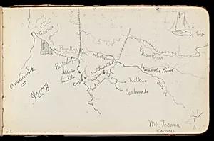
Map of Region Northwest of Mount Tacoma (from Sketchbook)
1890
Medium
Graphite on wove paper
Dimensions
4 3/4 x 7 3/4 in. (12.1 x 19.7 cm)
Classification
Drawing
Culture
American
Department
The American Wing
Museum
Metropolitan Museum of Art, New York, NY
Credit
Bequest of Marguerite H. Rohlfs, 1995
Accession Number
1995.379.4iii recto
Rights
Public Domain
Tags
Art Historical Context
Nestled in Albert Bierstadt's sketchbook 1890, *Map of Region Northwest of Tacoma* offers a rare glimpse into the meticulous preparatory work of one of America's foremost landscape artists. Bierstadt, a leading figure in the Hudson River, was renowned for his luminous, epic paintings of the American West. This small graphite drawing on wove paper—measuring just 4 3/4 x 7 3/4 inches—captures the rugged terrain of Mount Tacoma (now Mount Rainier) in Washington Territory, blending topographic precision with artistic observation during his late-career expeditions. Created at the tail end of the Gilded Age, when Manifest Destiny's fervor still fueled exploration of the frontier, the map reflects Bierstadt's deep engagement with the Pacific Northwest's sublime wilderness. Unlike his grandiose oil canvases, this intimate sketch reveals his on-the-ground process: quick, detailed lines delineating rivers, ridges, and valleys, likely informing larger compositions that romanticized America's natural grandeur for Eastern audiences. Housed in The Metropolitan Museum of Art's American Wing, this bequest from Marguerite H. Rohlfs underscores its cultural value as a document of 19th-century American expansion and artistic innovation. Wove paper's smooth texture allowed for fine graphite shading, making it an ideal medium for such portable fieldwork, bridging science and art in Bierstadt's enduring legacy.
About the Artist
Albert Bierstadt · 1830–1902
Albert Bierstadt (1830-1902) was a German-American landscape painter renowned for his monumental, luminous depictions of the American West. As a prominent member of the second generation of the Hudson River School and the Rocky Mountain School, Bierstadt created sweeping panoramas that captured the sublime grandeur of untamed wilderness with unprecedented theatrical scale and romantic vision. His ...