
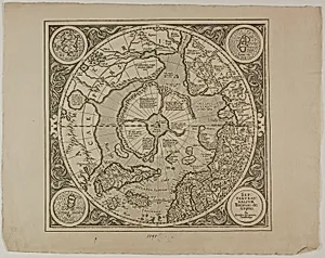
Map of the Mercator Projection
1595, reprinted 1889
Medium
Engraving in black on cream laid paper
Dimensions
25.6 × 32.9 cm (10 1/8 × 13 in.)
Classification
reproduction
Department
Prints and Drawings
Museum
Art Institute of Chicago
Accession Number
152512
Rights
Public Domain
Art Historical Context
Step into the world of Renaissance cartography with this *Map of the Mercator Projection*, an engraving from 1595, thoughtfully reprinted in 1889. Created by an unknown artist, this reproduction captures the innovative worldview of Gerardus Mercator, whose 1569 projection transformed navigation forever. By stretching landmasses toward the poles to preserve angles, it allowed sailors to plot straight-line courses on charts—rhumb lines—that corresponded to constant compass bearings, a breakthrough for the Age of Exploration. Rendered in precise black lines on cream laid paper (25.6 × 32.9 cm), the engraving technique exemplifies the era's mastery of copperplate printing. This medium enabled intricate detail and mass production, making advanced maps accessible beyond elite circles. Housed in the Art Institute of Chicago's Prints and Drawings Department, it highlights how visual tools bridged science and art, fueling global voyages from Europe to the New World. Though a reproduction, this piece invites us to ponder humanity's quest to chart the unknown, blending mathematical genius with aesthetic clarity in a compact, elegant form.
About the Artist
Unknown
The artist designated as "Unknown" in our virtual museum's collection exemplifies a poignant chapter in art history: creators whose identities have faded into obscurity despite the enduring power of their work. With only one known artwork attributed to them in our holdings, this figure represents countless anonymous hands that shaped visual culture across centuries. Museums worldwide, including th...