
清 佚名 中國地圖 屏風|Map of China
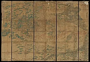
Medium
Eight hanging scrolls; ink and color on silk
Dimensions
Approx. each: 15 3/4 x 96 in. (40 x 243.8 cm)
Classification
Paintings
Culture & Period
China · late Ming dynasty (?) (1368–1644)
Department
Asian Art
Museum
Metropolitan Museum of Art, New York, NY
Credit
Gift of Yamanaka & Co., 1925
Accession Number
25.21a–h
Rights
Public Domain
Tags
Art Historical Context
This exquisite set of eight hanging scrolls, known as *Map of China* (中國地圖屏風), offers a rare glimpse into late Ming dynasty (1368–1644) cartography, though its precise date remains unknown. Created by an unidentified artist using traditional ink and color on silk, each scroll measures about 15¾ × 96 inches (40 × 243.8 cm), designed to unfold as a grand screen for immersive display. Acquired as a gift from Yamanaka & Co. in 1925, it now graces the Metropolitan Museum of Art's Asian Art collection. In imperial China, maps like this were vital tools for governance, military strategy, and exploration, blending scientific precision with artistic elegance. The silk medium—prized for its luminous sheen—allowed delicate ink lines to delineate rivers, mountains, provinces, and cities, while vibrant colors highlighted administrative boundaries and natural features. This format reflects the Ming era's scholarly fascination with geography, influenced by Jesuit-introduced Western techniques amid native traditions. As both functional artifact and decorative masterpiece, the scrolls embody China's sophisticated fusion of art and knowledge, inviting viewers to trace the empire's vast contours and ponder the era's worldview. A testament to anonymous craftsmanship, it captivates with its historical depth and visual harmony.