
Panel (Map)
1784
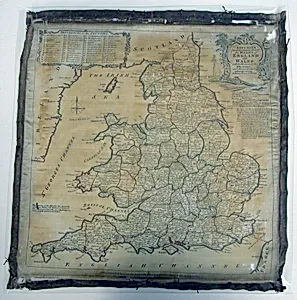
Medium
Silk, plain weave; printed
Dimensions
35.6 × 35.6 cm (14 × 14 in.)
Classification
textile
Department
Textiles
Museum
Art Institute of Chicago
Accession Number
23436
Rights
Public Domain
Art Historical Context
This exquisite silk panel, titled *Panel (Map)* and dated 1784, visitors to explore the intersection of cartography and textile artistry from the late 18th. Measuring a perfect square at 14 × 14 inches, it exemplifies the era's innovative use of printed silk on a plain weave foundation—a technique that allowed for vibrant, detailed designs on luxurious fabric. Produced anonymously, likely in a European workshop, the panel transforms geographical knowledge into wearable or decorative art, blending utility with elegance. In the context of 1784, just after the American Revolution, printed textiles like this surged in popularity for fashion accessories, furnishings, and even propaganda. Silk's sheen and durability made it ideal for capturing intricate map details through block-printing or early mechanical methods, democratizing maps beyond paper for the affluent home. Housed in the Art Institute of Chicago's Textiles Department, it highlights how fabrics served as canvases for education and cultural exchange, reflecting Enlightenment curiosity about the world. Though the specific map's subject remains a tantalizing mystery, its preservation underscores the fragility and allure of historic textiles—once vibrant in drawing rooms, now a window into 18th-century ingenuity. Pause here to imagine it draped as a shawl or wall hanging, mapping adventures yet to unfold.
About the Artist
Unknown
The artist designated as "Unknown" in our virtual museum's collection exemplifies a poignant chapter in art history: creators whose identities have faded into obscurity despite the enduring power of their work. With only one known artwork attributed to them in our holdings, this figure represents countless anonymous hands that shaped visual culture across centuries. Museums worldwide, including th...